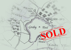
Groby Sold in 1925!
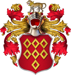
Did you know that most of Groby was sold in 1925? Since the late Middle Ages, Groby was an estate village belonging to the Grey family, the Earls of Stamford and Warrington. The coat of arms of the 8th Earl are in the church in a diamond-shaped frame and the shield is on the sign of the Stamford Arms. You can see the blue and white stripes and the boars heads on the shield.
Anyway, after the death of the 8th Earl, Lady Venetia Grey decided to sell off the estate. Many of the cottages were sold to the tenants occupying them.
sold
What was the centre of the village like in 1925? Well, the population in 1921was only 887. (In 2001 it was 7,355).
There were 6 farms and some small holdings and 30 of the cottages were still thatched. Many of the buildings were made of Groby granite with Swithland slate rooves or rather “Groby slate” as I like to call it, as it would all have come from the slate pits in the village. You can recognise local slate because it is very thick. It does not split well so the slates at the ridge of the roof are much smaller than those at the eaves. This grading of the slates was done to save weight on the rafters. Brick buildings with welsh slate rooves came later. Only the houses of the most well-off residents, such as the farmers, would be 3 storeys high, the rest were all 2-storey.
There were only a few streets. On Leicester Road, the house nearest to Leicester was just below the top of the hill, opposite the modern post office. It is the double-fronted brick-built house which is still there. On the post office side was and is a row of brick terraces and then the Stone Row cottages. Crown Cottage was thatched, then a couple of stone cottages which later became the skittle alley of the pub, and the Stamford Arms itself.
Some of the old cottages still remain in Rookery Lane. (There was no road through to Pymm Leys field track.) So, at the corner of the Rookery and Rookery Lane there was a yard of crowded cottages that were pulled down later, in the 20th century. A rookery in this sense, means an area of housing for poor people who could only afford to rent a house or part of a house in an area where they had to live very tightly packed together.
Turning up Ratby Road, on the left, there is little change as far as the old Co-Op, now Cathy Stephens, the jewellers. Next came a large farm, where Crane Ley Road refers to the last farmer. Chapel Hill existed but not, of course, the modern houses. From the thatched cottages onwards, Chapel Hill has changed little but the old chapel was pulled down after Coronation Year, 1953 and the new modern chapel was built. Between the chapel and White House (White House Close) there were no houses, but a muddy track across two fields. The White House, then known as Cowpen Cottage, was quite isolated in the middle of the fields and remained so until at least the 1960s.
The Allotments on Ratby Road, existed of course, so the quarrymen could grow home-grown vegetables for their families. On the left-hand side, towards Ratby, there were no houses until you reached Brook Vale Cottages. Along this length the mineral railway line from the quarries, ran beside the road down to the “main line near Desford”.
Returning from Ratby, the first houses you met, were Victoria Cottages. The stone built block of 4 households at the top of the hill, was there in 1925. Opposite the brick terraces of houses still on the south east side of Ratby Road, was a very similar, long row on the north west side. These houses were 2-up and 2-down and originally had shared outside toilets.
Towards the bottom of Ratby Road on the left was the entrance to the quarry and the railway line. Around the (railway) Wharf were some large brick buildings including the engine shed. The four-square stone house of a quarry manager still remains in line with the old railway. Just short of the bottom of Ratby Road, some of the cottages still remain, now including the chemists and the hairdressers. There was a cruck-built cottage there until the 1960s when its arched timbers were revealed as it was pulled down. The oldest small house in the village is opposite and just inside Rookery Lane. The cottage is now known as the Blacksmiths Cottage although the only connection is that the forge lay close to it. It is thatched and timbered and the spaces between the timbers were filled in with wattle and daub, that is interwoven small hazel branches and mud. The wattle and daub has been replaced by bricks.
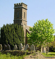
Turning the corner past the (1925) post office (now the Delicatessen) into Markfield Road, the stone cottages as far as the thatched one nearly opposite the church would have been there in 1925. So also would the cottages up the hill to the 2 thatched cottages just short of the modern bypass (built in the early 1960s.) Returning to the centre of the village, Old Cottage is old, much older than the church which was built in 1840.
The castle mound, hidden behind the church, next to the bypass, was sleighted in 1127.so the mound was obviously visible in 1925. (The lord of the manor offended the king so he sleighted the castle [knocked one side of it down] so he would have no more trouble from Groby.)
Next comes the Old Hall. What we see is only a small remnant of a very large complex of buildings. Construction probably started about the time the castle was sleighted. The Old Hall grew and diminished over the centuries.
Back to 1 Leicester Road, Chaplins, the butchers, complete with slaughter house. Cows were slaughtered in the village in living memory but thereby hangs another tale! The Chaplins’ house would still have been thatched in 1925. Where the new Co-op has its car park, was still part of the farmyard of the Old Hall. Behind the bus stop was a different, older stone wall and the sheep dip, fascinating to watch – I remember! There were no houses in Newtown Linford Lane so back to the village school.
There were two schools buildings in the village in 1925, that became the Infants and Junior Schools by the 1950s. These are the two stone buildings opposite the modern post office, now the Village Hall and a private house. The schools had a total of 6 classrooms, the 2 rooms in the smaller older building were used by the Infants. There was no hall (in what is now the Village Hall) unless the partition between 2 of the rooms and the desks were pushed back. Toilets were in the yard.
I have mentioned all the roads and streets that existed in 1925 and by the 1950s there had been no change except that a moderate number of semi-detached houses had been built along the Leicester Road, Marina Drive and Wallace Drive. It was in the 1960s and 1970s that Groby began to grow and grow and grow!
Do you know better? Do you remember more?
Tell us your memories of Groby – we can record them, we are trained to record and eager to listen. If you prefer, write down your memories yourselves and let Groby Heritage Group have a copy. We do have a copyright statement for you to agree so that your keep control over what happens to your memories.
We all know so much about Groby but will our children?